

In brief: Understanding Boundary Disputes and Resolution Options
The question: How can residential and commercial property owners in England and Wales resolve entrenched boundary, fence, or encroachment disagreements without incurring £50,000 or more in County Court costs or compromising property saleability under Law Society conveyancing rules?
The short answer: Under Section 60 of the Land Registration Act 2002, HM Land Registry title plans show only general boundaries; the red line mapped on a title plan cannot prove precise property lines on the ground. Litigating fractional boundary slivers in the County Court or First-tier Tribunal frequently incurs £50,000 to over £100,000 plus VAT per party and triggers serious cost penalties under CPR Part 44 for unreasonably bypassing alternative dispute resolution. Unresolved disputes also create immediate conveyancing blight under Law Society Form TA6 disclosures, stalling sales and risking post-completion misrepresentation claims. By following the Boundary Disputes Protocol, commissioning a Single Joint Expert surveyor, and engaging in structured neighbour dispute mediation, adjoining owners can negotiate binding Boundary Agreements (Form AP1) or Determined Boundaries (Form DB). This approach resolves boundary ambiguity, satisfies conveyancing disclosure requirements, and delivers enforceable legal certainty without trial costs.
The General Boundaries Rule: Why Title Plans Do Not Fix Exact Lines
A widespread assumption among freehold property owners is that the red line on an HM Land Registry title plan guarantees the exact legal boundary of their property down to the millimetre. Under English land law, this assumption is incorrect.
Section 60(1) of the Land Registration Act 2002 provides that the boundary of a registered title as shown on the title plan is a general boundary only, unless it has been formally determined under Section 60(3). Title plans are derived from Ordnance Survey mapping, typically at scales of 1:1250 in built-up urban settings or 1:2500 in rural environments. At a 1:1250 scale, the physical width of the red line printed on the title plan equates to roughly 0.3 to 0.5 metres on the ground. In rural areas mapped at 1:2500, that same printed line can span more than a full metre.
Ordnance Survey maps represent physical features on the ground at the date of survey—such as fences, hedges, kerbs, and embankments—rather than underlying legal boundary lines. When an adjoining owner replaces a wire fence with a timber fence, plants a hedge, or erects an outbuilding near the boundary, disputes often arise because parties attempt to measure millimetres using a ruler against an enlarged title plan.
Determining the true legal boundary requires analysing historical pre-registration title deeds, particularly the original root conveyance or transfer deed that initially partitioned the land. When the conveyancing deed describes boundaries as “delineated for identification purposes only”, courts and tribunals look to extrinsic evidence: historical photographs, topological features, physical markers present when the land was conveyed, and historical patterns of occupation. Relying solely on a Land Registry title plan to claim ownership over a narrow strip of ground has no solid basis in property law.
Conveyancing Realities: Law Society Form TA6 Disclosures and Sale Blight
While the physical argument on site often involves a garden fence, a shared driveway, or overhanging eaves, the immediate financial risk lies in property conveyancing. When an owner sells or remortgages residential property in England and Wales, their conveyancer will require the completion of the Law Society Property Information Form (TA6).
Form TA6 places sellers under a clear obligation to declare boundary maintenance agreements and encroachments (Section 1, Boundaries), neighbour disputes and complaints (Section 2, Disputes and complaints), and formal communications (Section 3, Notices and proposals). Specifically, sellers must disclose:
- Any disputes with adjoining neighbours or complaints regarding the property, whether ongoing or historic.
- Any notices or letters sent to or received from a neighbour concerning boundaries, maintenance, access, or alleged encroachments.
- Any formal or informal agreements regarding the maintenance, repair, or erection of boundary structures, walls, or fences.
Concealing a boundary dispute carries severe legal exposure. A vendor who fails to disclose an active dispute on Form TA6 faces claims for damages or rescission under the Misrepresentation Act 1967 if the buyer later uncovers the conflict. Such claims frequently leave the seller liable for the diminution in property value, along with the buyer’s legal expenses and court costs.
Conversely, disclosing an open, unmanaged boundary dispute can lead prospective buyers to withdraw, renegotiate price reductions, or face mortgage lender refusals. Resolving property line friction through civil disputes mediation converts an active conflict into a formal, documented settlement. An executed agreement or registered Land Registry instrument allows the seller to declare the historical dispute on Form TA6 alongside proof of its definitive legal settlement, removing conveyancing blight.
Civil Court Cost Risks and Judicial Expectation of ADR
Pursuing a boundary dispute through the County Court or the First-tier Tribunal (Property Chamber) involves substantial financial and procedural risk. Contested boundary trials can be disproportionately expensive, with practitioner estimates and case reports showing legal costs frequently ranging from £50,000 to over £100,000 plus VAT per party across solicitors’ fees, specialist land surveyor fees, and trial counsel briefs.
The judiciary maintains strict expectations regarding proportionality in minor land disputes. Under CPR 44.2(5)(e), civil courts exercise broad discretion over costs and actively assess the conduct of the parties before and during proceedings, including whether a party unreasonably refused to engage in ADR.
This approach was confirmed by the Court of Appeal in Churchill v Merthyr Tydfil CBC [2023] EWCA Civ 1416, which affirmed that civil courts have the power to stay proceedings and direct parties to participate in mediation or non-court dispute resolution, provided access to justice is not impaired. As examined in legal commentary on analyses of Churchill v Merthyr Tydfil, this authority has reinforced judicial willingness to penalise parties who bypass mediation.
The practical consequence is significant: even a party who secures a declaration confirming their boundary line by a few inches may be deprived of their costs, or ordered to pay a portion of their neighbour’s costs, if they unreasonably refused an offer to mediate. Securing title to a fractional strip of land while absorbing tens of thousands of pounds in unrecovered legal fees represents a serious commercial loss.
Evaluating Resolution Routes: Costs, Timelines, and Legal Finality
Property owners and their legal advisers generally evaluate three procedural routes when addressing a boundary deadlock. The financial, temporal, and practical implications of each route differ substantially.
| Resolution Route | Typical Timeline | Cost Range (Per Party) | Flexibility of Remedies | Resale / TA6 Form Impact | CPR Costs Risk |
|---|---|---|---|---|---|
| County Court / FTT Trial | 12 – 24 months | £50,000 – £100,000+ (plus VAT) | Rigid / Binary: Court only declares legal boundary or trespass; no commercial trade-offs. | Severe Blight: Active litigation must be disclosed; sales routinely collapse or stall. | High Risk: Discretionary costs; severe sanctions if ADR was rejected pre-trial. |
| Facilitative Civil Mediation | 2 – 6 weeks | £1,000 – £3,000 | Highly Flexible: Can agree land swaps, shared fence costs, easements, or cash compensation. | Cures Blight: Produces binding settlement document clearing dispute status for buyers. | Protected: Full compliance with CPR 1.4, CPR 44.2, and Pre-Action Protocols. |
| HMLR Determined Boundary (Form DB) | 3 – 9 months (uncontested) | £2,000 – £6,000 (survey + legal) | Technical Only: Fixes line to ±10mm accuracy; cannot resolve ancillary disputes/damages. | Conclusive: Converts general boundary to determined exact boundary on register. | Medium: If an adjoining neighbour objects and the objection is not groundless, HMLR refers the matter to the FTT if unresolved by agreement. |
As explored in our analysis of mediation vs litigation in the UK, formal adjudication is limited to binary outcomes: the court determines who owns the strip on a strict legal basis. It cannot order practical compromises, such as granting a reciprocal access licence, agreeing cost-sharing terms for an acoustic fence, or adjusting physical boundaries alongside nominal financial compensation. Mediation provides the necessary procedural space to structure these pragmatic, binding arrangements.
The Boundary Disputes Protocol: A Structured Pre-Action Framework
To avoid disproportionate litigation, property practitioners established the Boundary Disputes Protocol for Property Protocols, endorsed by the Property Litigation Association. While not a formal CPR pre-action practice direction, civil judges place substantial weight on whether adjoining owners have complied with its principles before initiating proceedings.
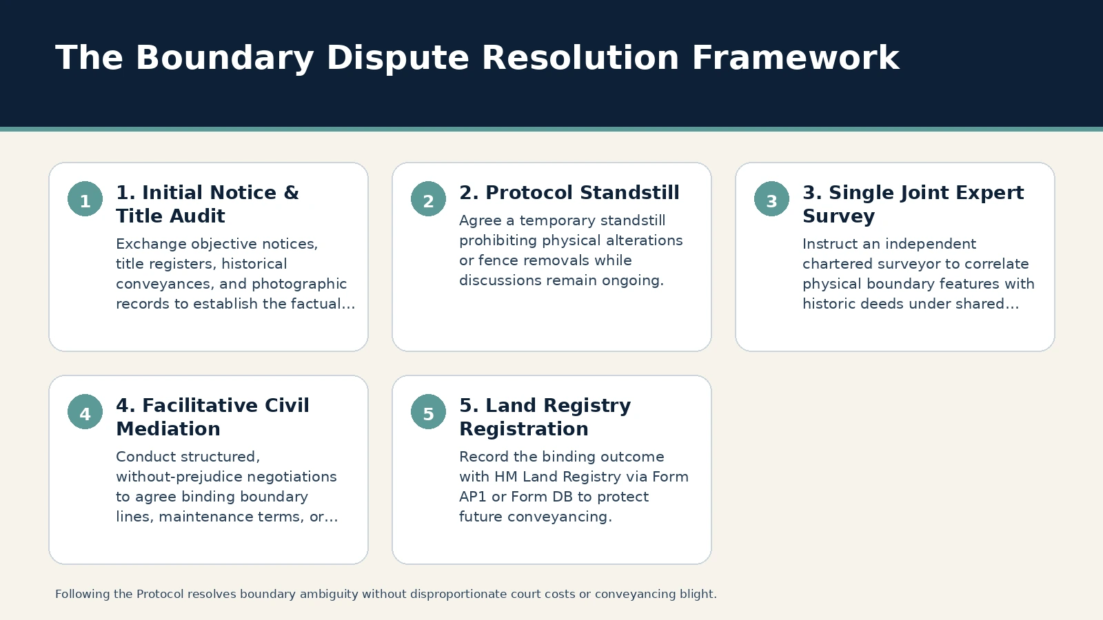
The Protocol establishes an orderly sequence for resolving boundary conflicts without immediate court action:
1. Initial Notification and Information Exchange
Rather than issuing contentious correspondence, the initiating owner sends a clear, objective letter identifying the disputed physical feature (such as a fence line, wall, outbuilding eaves, or hedge). Within two to four weeks, both parties exchange relevant title registers, filed title plans, historical conveyances, pre-purchase survey reports, and dated photographs showing the history of the boundary alignment.
2. Standstill on Physical Alterations
The parties enter a temporary standstill agreement: neither party will dismantle fences, remove hedging, or carry out structural building works along the disputed strip while discussions are ongoing. Unilateral physical intervention invariably inflames tensions, prompts applications for emergency interim injunctions, and inflates legal costs.
3. Instruction of a Single Joint Expert (SJE)
A frequent procedural error is commissioning competing boundary surveys. When each owner hires their own surveyor, the resulting reports often conflict, entrenching positions while doubling surveying costs.
The Protocol encourages the joint instruction of an independent Single Joint Expert (SJE) chartered land surveyor under agreed Terms of Reference. The SJE inspects the site, examines historic root conveyances, conducts high-precision geodetic measurements, and produces an objective report correlating the physical features on the ground with the title deeds. The parties share the surveyor’s costs equally.
4. Convening Facilitative Mediation
With the SJE survey establishing the factual baseline, the parties enter a confidential, without-prejudice mediation session. The mediator facilitates structured negotiations addressing boundary positioning, fence specifications, maintenance covenants, and legal documentation. This process addresses interpersonal concerns alongside technical findings, producing a workable, lasting resolution.
For further detail on structured negotiations, see our guide on mediation, ADR, and settlement strategy.
Recording the Resolution with HM Land Registry
A mediated settlement agreement functions as a binding contract between the participating owners. To ensure the agreement binds subsequent owners and protects future property sales, the agreed boundary must be recorded on the title registers in accordance with property and real estate conveyancing standards.
Under HM Land Registry Practice Guide 40, parties can register the outcome using one of two established mechanisms:
Boundary Agreements via Form AP1
Under English common law and HM Land Registry Practice Guide 40, an agreement identifying an uncertain boundary line on the ground does not constitute a disposition of land requiring a contract in signed writing under Section 2 of the Law of Property (Miscellaneous Provisions) Act 1989, nor a formal transfer deed under Section 52 of the Law of Property Act 1925.
The parties execute a formal Boundary Agreement referencing an agreed plan that defines the boundary line relative to physical reference points. This agreement is lodged with HM Land Registry using Form AP1 alongside the required fee. The Land Registry records a standard note on the title register of both properties confirming that a boundary agreement has been deposited, binding successors in title.
Determined Boundary Applications via Form DB
When parties require exact precision that formally replaces the general boundary on the register pursuant to Section 60(3) of the Land Registration Act 2002, they submit an application for a Determined Boundary using Form DB.
Form DB applications require a detailed expert survey plan accurate to within ±10 millimetres, tied to permanent physical ground features or Ordnance Survey National Grid coordinates. Once approved by HM Land Registry, the determined boundary is recorded on both title plans, removing general boundary ambiguity. If an adjoining owner objects to a Determined Boundary application and the objection is not groundless, HM Land Registry refers the matter to the First-tier Tribunal if the dispute cannot be settled by agreement.
Instructing conveyancers to lodge either Form AP1 or Form DB following mediation completes the legal process, giving both owners clean title documentation that satisfies all disclosure obligations under Law Society Form TA6.
Frequently asked questions
Why doesn’t my Land Registry title plan show the exact boundary down to the inch?
Under Section 60 of the Land Registration Act 2002, HM Land Registry title plans show only “general boundaries”. Title plans are based on Ordnance Survey maps, usually at 1:1250 scale in towns or 1:2500 in rural areas. At these scales, the printed red boundary line represents several inches or even feet on the ground. A title plan confirms the general extent of a property but does not determine the exact legal boundary line to the millimetre unless a formal Determined Boundary application has been registered.
What happens if my neighbour refuses to mediate our boundary dispute?
Under Civil Procedure Rule 44.2 and Court of Appeal authority in Churchill v Merthyr Tydfil CBC, civil courts actively review whether parties engaged in alternative dispute resolution. If a neighbour unreasonably refuses mediation and forces court proceedings, the judge can penalise them in costs—even if they succeed on their substantive boundary claim at trial. These penalties include depriving the winning party of their legal fees or ordering them to pay a portion of the opponent’s costs.
Do I have to disclose an informal fence dispute when selling my property?
Yes. Law Society Property Information Form TA6 requires sellers to declare boundary maintenance agreements and encroachments (under Section 1, Boundaries), neighbour disputes and complaints (under Section 2, Disputes and complaints), and relevant notices (under Section 3, Notices and proposals). Failing to disclose a known dispute exposes you to actionable claims for misrepresentation and damages under the Misrepresentation Act 1967 after completion. Resolving the matter formally through mediation allows you to disclose the dispute as fully resolved with binding legal documentation.
What is the difference between a Boundary Agreement and a Determined Boundary?
A Boundary Agreement (recorded via HM Land Registry Form AP1) is a legal document where adjoining owners agree on the line of an uncertain boundary on the ground. A Determined Boundary (applied for via Form DB) is a higher-precision procedure requiring a detailed survey plan accurate to within ±10mm tied to permanent physical features or National Grid coordinates. A Determined Boundary formally replaces the general boundary on the Land Register with an exact legal line.
Why should we instruct a Single Joint Expert surveyor rather than our own surveyor?
Instructing individual surveyors frequently leads to conflicting reports that entrench disagreement while doubling expert costs. A Single Joint Expert (SJE) chartered land surveyor is instructed jointly by both neighbours under agreed Terms of Reference. The SJE provides an objective, independent technical assessment of the deeds and physical ground features, cutting professional fees in half and providing a neutral factual foundation for mediation.
Authoritative UK guidance and further reading
Primary and official sources
- Land Registration Act 2002 (legislation.gov.uk)
- Practice guide 40: HM Land Registry plans, supplement 4, boundary agreements and determined boundaries – GOV.UK (gov.uk)
- Exact line of boundary: registration (DB) – GOV.UK (gov.uk)
- Courts and Tribunals Judiciary (judiciary.uk)
- HM Land Registry plans: boundaries (practice guide 40, supplement 3) – GOV.UK (gov.uk)
- Practice guide 40: guide overview of Land Registry plans – GOV.UK (gov.uk)
- Land Registration Act 2002 (legislation.gov.uk)
- HM Land Registry plans: title plan (practice guide 40, supplement 5) – GOV.UK (gov.uk)
This guide provides general information about dispute resolution and mediation. It is not legal advice. The appropriate approach depends on the facts, documents, procedural position and the parties involved; obtain legal advice where required.